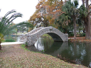
In this project about City Park, my goal is to give
a brief history of the Park, as well as to inform readers of how the Park has
changed over time. My primary goal is to compare and contrast two sections of
the Park: the section of the Park that contains the museum and lagoons, and the
west and east gulf courses that were damaged and left unrepaired after
hurricane Katrina.
To
begin, let’s focus on what most people think of as “City Park”, the area that
contains the New Orleans Museum of Art and sculpture garden. Before development,
the land was first occupied by the Accolapissa and Biloxi tribes. Eventually, the main area of the Park was first
developed from swamp land to farm land in the mid-1800’s. It was originally a sugar
plantation owned by the Allard family. In time, the land was foreclosed on and
willed to the city of New Orleans in1854. In 1891, Victor Ansmen created the
CIOA or City Park Improvement Association. This marked the beginning of the
true development of what we now know as City Park. Throughout the park, you can still see
remnants from Roosevelt’s WPA crews that created many of the historical bridges
and dug the eleven miles of lagoons in the Park. The New Orleans Museum of Art
was built in 1911. It is easy to forget, when walking around this urban area,
that this part of the Park, along with all the land around it, was once swamp
land. While it was inevitable that, with time and increasing population, the
environment would change. In my opinion, it is important to balance this shift
toward urbanization that can be seen in this part of the Park, with those areas
that represent, to some extent, the original form of the environment and have
shifted in the opposite direction of urbanization. In this post, I have attached some past and
present pictures of City Park to give a sense of the history of the Park. In my next post, I will discuss the
de-urbanized sections of City Park to give an idea of contrast.


No comments:
Post a Comment